Bigbury And the South Blean Earthworks: in context with recent research
Talk by C. Sparey-Green
Date: SEPT . 28th, 7.30pm
Venue: Lenham Hall (Groom Way)
Held by: LENHAM HERITAGE GROUP
Cost: £2 – Non members most welcome
Talk by C. Sparey-Green
Date: SEPT . 28th, 7.30pm
Venue: Lenham Hall (Groom Way)
Held by: LENHAM HERITAGE GROUP
Cost: £2 – Non members most welcome
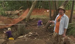
Hugh Marley has kindly put together a short film on this year’s dig at Cobham. See some of our team in action (with local cows munching in the background) and let Andrew explain what we found and how it has been interpreted.
Thank-you Hugh.
Venue: Rutherford College, Lecture Theatre 1 and 2, University of Kent at Canterbury CT2 7NX
Tickets: £25 (£20 KAS members)
Timetable:
10.00 – 10.30 Coffee and registration
10.30 – 13.00 Introduction, Session 1 – 4 (Becoming Roman a perspective, 34 kilometres of Romans, Ragstone to Riches, Controlled or spontaneous? The pattern of Roman Settlement in Central North Kent)
13.00 – 14.00 Lunch
14.00 – 15.25 Session 5 – 6 (Pottery, beer and salt: the north Kent coast as a corridor of trade and industry, Local landscapes: two case studies from the Canterbury Hinterland Project)
15.30 – 16.00 Break for tea
16.00 – 17.00 Session 7 – finish (Villas of North-East Kent)
Session details and booking form: Visit the KAS website
Otto Bagi (from the Institute of Archaeology, University of Warsaw) was back this year to create 3D models of two tiles finds from Randall Manor and the cricket mug from the Mausoleum Cottage dig.
Click the links to go to the models:
Medieval floor tile (geometic decoration)
Medieval floor tile (lady of the manor)
Thank-you Otto!
Our beady eyed volunteer, Pauline, has come across this fabulous fossil:
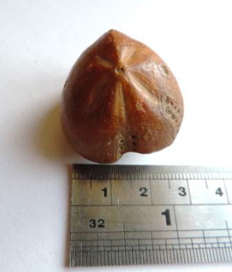
It is an echinoid fossil – an ancient sea urchin. This particular fossil is approximately 65-145 million years old ,from the Cretaceous period. It was found in a field near the barn at the end of Lodge Lane, Cobham.