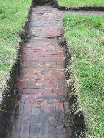
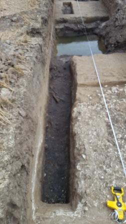
Jack Hollis: memories of Ashenbank and Shorne Woods

The family and Ashenbank Camp

My Mum was born in Glyncorrwg Wales, and Dad was born  in Houghton-Le-Spring County Durham. I was born in Chesterfield, Derbyshire on the 26th September 1944. I have an elder Brother Ray and four Sisters, Eunice, Rita, Linda and Sandra. After the war, with Mum and Dad’s approval, Ray was naturally adopted by Auntie Dora and Uncle Len they migrated back to Guernsey, Uncle Len’s birth place.

Mum, Dad, my elder sister Eunice and myself lived for a while in Lynton road South Gravesend, we then moved in to a disused RAF camp in Ashenbank woods, the hut had been Officers Quarters when the RAF were billeted there. I have been told that we were the first squatters on the camp but I can’t confirm it, our address was 34 Laughing Waters Cobham Kent. In later years my three younger sisters were born while we lived there.

It was a single storey wooden hut with a tarred felt roof, the inside was painted cream and there was brown lino on the floor. I can’t quite remember the layout of the building but there was a passageway along the centre of the building with three rooms on either side of it. Looking at the hut from the front, the kitchen was on the left, the living room was next, I can’t remember the third room at the front but the three rooms at the back were bedrooms. I can remember my dad building a bed out of timber that he brought home from work.

Unlike most of the buildings that had to share toilet blocks, we had our own toilet a short distance from the hut [to the left of the tree in the photo ]. There was no bathroom but we had a tin bath which was filled from water boiled on the Kitchener.

34 Laughing Waters Cobham Kent

34 Laughing Waters Cobham Kent

Life in the area

When I started at Cobham Primary School I caught the bus at Shepherds Gate into Cobham village. Mr Aldridge was the headmaster of the school, a very stern Yorkshire man. He is the only teacher that I can remember the name of. Mum would use the bus for her shopping trips to Gravesend. It went via Halfpence Lane, the Tollgate and on into Gravesend.

There was a general store on the site, which had probably been the NAAFI building as it didn’t look like the rest of the huts. We could also go into Ganders general store in Cobham village.

Mum worked for Lord Darnley as a domestic in Cobham Hall and at Scalers Hill House. As a family we would gather sack loads of Chestnuts, which I assume Lord Darnley sold. Mum also worked at some time at the Laughing Waters Restaurant just off the A2, it is now known as the Inn on the Lake. Dad turned his hand to various jobs including as a Blacksmith and window cleaning. We also helped as beaters for pheasant shoots on the estate.

I don’t remember many names from the camp except for the Tovey family who lived next door to us, they had a daughter Susan that my sisters played with, also there were The Murrells on Camp site 5 and the Coleman family who lived in the area of hut number 40/42 (Mr Coleman was a coalman!).

Entertainment

There were no playgrounds in the camp, nothing put on for the children so we had to make our own entertainment, except for the Christmas party at the Meadow Rooms in Cobham village, and the occasional film show in the loft of the village bakery – that was quite an exciting event.

Inside Shepherds Gate there was a thatched roof cottage with a large barn. We played in the barn on bales of hay and old farm machinery that were stored there. nother place was the Brick Kiln ponds, one winter when the ice was so thick we were jumping up and down trying to break it, luckily we didn’t, or we might not be here now.

We used to watch the Blacksmiths in Cobham village shoeing the horses while waiting for the bus home from school, occasionally we used to go to the bakers for a ‘penny bag of stales’, in those days they used to be able to sell stale cakes! Blackberry picking at Scalers Hill was another summer pastime.

Sports car and motorcycle time trials were held, starting in large silver sand hollow near the bridge that now crosses the A2 to Thong lane. The motorcycles and cars would scramble up steep inclines sometimes not making it to the top, down steep banks and through muddy water filled ditches on to roads at speed through the woods. Being mischievous children we took great delight in turning round the marker flags.

There used to be a tea wagon parked on the A2 where lorries pulled in for a break, and at weekends coaches would pull in for a halfway stop on their way to the coast, they would get out crates of beer and food and have a jolly good booze up.

On the left hand side of a lane leading downhill from Brewers Gate to the golf club (probably the Old Roman Road) there was a high sand bank where Sand Martins nested and a stream with watercress growing in it on the right hand side. Further in the woods towards Cobham Hall I recall a sunken white tiled area, possibly the area marked on the Ordnance Survey map as fish pond.  When the A2 was widened in 1960, I wasn’t surprised to hear that there were problems with subsidence in this area due to the sandy banks.

We probably moved out of the camp in 1955/6, confirmed by a family postcard dated 21.3.55 with 34, Laughing Waters as the senders address and also a medical certificate for my sister Rita from  Northcote Primary school dated 21.6.56.

We were offered a new house in Higham but we didn’t take up the offer. With my father being in and out of work it may have been too expensive and moved to Shamrock Road in Denton instead.

One of my main playgrounds was the clay works in what is now Shorne Country Park but that’s another story.

Jack talks about the clay pits in Shorne Woods

I have fond memories of my sisters and friends playing in the clay works on the other side of the A2, now known as Shorne Country Park. We used to watch the big digger load buckets full of clay onto the rubber conveyor belts that ran on two short V shaped upright rollers and one wide flat one underneath to move the belt. There were large gaps between the clay on the conveyors while the digger dug the next load so we used to jump on the belt for a ride but were often chased off by an employee. The belt ran right across the clay pit from the Brewers Road end to the slurry tank near the A2.

From another part where clay was dug there was a small narrow gauge railway track with an incline up to a large hopper. The engine was possibly a coal fired box shape. It hauled V shaped wagons which had a central pivot up the incline and they could tip either way up into the hopper, where they were tipped out to a fleet of open back lorries waiting below. I think each wagon load was one lorry load. They were then transported off possibly to Aylesford.

When work finished for the day we would play on the tipper wagons rocking them from side to side. I also recall helping ourselves to coal from a large heap that was used to fire the engine. In the summer months we had hours of fun playing in the rain water pools that were only waist deep.

I recall a wide gravel path on the Shorne side of the A2 between Camp 2 and the Clay works going through Shorne Woods, leading down to a gatehouse at Thong Lodge. The path had iron bar fencing each side typically found on the Darnley Estate, there were red, yellow, white and pink rhododendrons growing on either side of the fencing.

(As told to Trevor Bent in 2017.)

Posted in Oral History | Tagged , | 4 Comments

Peter Beech: memories of Shorne, the airfields and Clay Works

I have lived in Thong for all of my 84 years, the first six weeks on the Shorne/Ifield Road and then two houses in Thong Lane. I have lived at my current address, Little Westwood, Thong Lane, Gravesend for the past 58 years.

Building homes

This is one of the houses that were originally built in 1922/23 as part of the ‘Homes for Heroes’ scheme after the First World War, of which there are several in Thong Lane, each had a barn and 10 acres of land. The Westwood name was taken from the farm that became part of the airport when it was built

To qualify for one of these properties you had to have been wounded or gassed during the war which helped people who would otherwise have found it difficult to get a job. If you were unable to cope with the amount of work required you could pass the land to your neighbour if they wanted it.

The houses at the top of Thong Lane were given names as when they built the houses at the bottom of Thong Lane they duplicated the numbers that were already being used at the top, the post kept going to the wrong houses so this was the easiest solution.

The local area

In the early days the water supply to Thong was from a spring in the woods, when ‘tadpoles’ started coming through the taps it was time to inform the Darnleys that the filter needed replacing!

From my front window I can look across the field to the trees in Brummelhill Wood and further up to where the ‘Clay Hill’ stood before the clay excavation took it all away, where once this was a big hill it is now lower than Brummellhill Wood.

Thong Lodge was the main entrance to Cobham Hall, the driveway crossing the Old Watling Street at Shepherds Gate. (Shepherds Gate and Brewers Gate were both gated entrances to Cobham Hall). My aunt and uncle were Gatekeepers at the Lodge, visitors would ring the bell to gain entrance and drive their horse and carriage to the Hall. In summer the public could pay 2d or 3d to do the ‘Rhododendron Walk’ through the woods and around the ‘Laughing Waters’ lakes (now Inn on the Lake). My aunt was in charge of the tea room that was on the ‘Wooded Lane’ (the Old Watling Street) where people would stop for afternoon tea.

St Thomas’ Well is a name I remember as being just over the old bridge over the A2 where there was a pond and two cottages but I don’t know if there was actually a well there, if there was I never saw it.

Clay works

The ‘secret lake’ (Randall Bottom Pond) was a lovely deep lake before the clay workings started but with the clay holding water they had to dig drainage ditches to enable them to carry on working and not become waterlogged, over the course of time this silted up the lake which became quite shallow.

The clay was excavated, using a navvy (this was before the days of JCB’s) in tiers about 10 feet high, once one level was finished they started on the next tier down, they did this four or five times so there must have been at least 50 feet of the hill taken away. The ‘navvies’ on the upper tiers were diesel and the ones at ground level were electric. The trees had been cut down prior to the clay excavation beginning but the roots that had been left, these were bulldozed over the edge into the clay pit as they came across them.

The ‘Crows Nest’ that was built by the Darnley’s, was on the highest point of the clay hill and built around the tallest tree. It could be reached from either of two tracks, one from Woodlands Lane and the other from Brewers Road (it is no longer there but was between the concrete road and the park entrance, nearly opposite a gate on the other side of Brewers Road). This track, which was quite steep before the clay extraction started, was used by Dykes small lorry to take 50 gallon barrels of diesel up to the ‘navvies’. At one point they installed a pipeline from Brewers Road to pump the diesel and a 600 gallon tank in the pit to receive the diesel The first time they tried to fill the tank it was still empty when the tanker was empty, all the diesel was still in the pipe, they had to get another tanker and pump that out to get the original delivery to the tank, they hadn’t worked out how to get the oil that was in the pipe line to the storage tank, I don’t know how long the pumping system lasted for!

Not far from the ‘Crows Nest’ was the army look out tower, both were demolished when the clay excavation reached where they stood. The tower was quite high and it was possible to see Crystal Palace from the top (Crystal Palace burnt down in 1936).

The entrance to the clay works was on the old Watling Street, roughly opposite Halfpence Lane. The clay working area was extremely waterlogged and ‘lakes’ formed and some areas were just like a bog, railway sleepers were put down to stop the machinery sinking in the clay.

One of the electric navvies motor burnt out and a replacement motor had to be brought in by Dykes Transport, unfortunately it got stuck in the clay part way up the hill, the concrete road was OK (this wasn’t put in until later) but further along Brewers Road the track towards the Crows Nest was just a rough track. My uncle, who was one of the navvy drivers, came and got me, with my tractor and trailer, from the farm where I worked, to see if I could get the motor up the hill. We had to cut down a few trees so that I could get up there but with the aid of a block and tackle we got the motor off the lorry onto my trailer. Once at the top of the hill we had to carefully lower the motor, using the block and tackle, balanced rather precariously on the edge of the pit, down to the navvy.

On the other side of the woods, near to Laughing Waters was the slurry tank, a big arm was used to mix the clay with water to make a slurry which was pumped to Bevan’s cement works at Northfleet. There was another pumping station at Northumberland Bottom in Coldharbour Road. A small locomotive pulled the tip trucks along the track to the slurry tank and as the excavation extended so was the track. Later on in the operation electric conveyor belts were used instead of the rail  trucks.

Part of the agreement with the Darnley family was that at the end of the excavation the ground should be levelled and replanted, this didn’t happen as there were big heaps of railway tracks and sleepers left after everything had been closed down. Towards the end of the clay extraction the concrete road (from the clay workings to Brewers Road) was put in and clay transported by lorry to the cement works at Snodland.

The Airfield

During the war the Air force commandeered Laughing Waters and the Army, Thong Lodge so my aunt had to move to the bungalow in Laughing Waters. Because this was a restricted area she wasn’t allowed any visitors except family, later she moved to Cobham College.

There was an army searchlight on Mill Hill but no guns, the only guns I know about were mounted on the backs of Lorries and were driven from place to place as required.

The look out post in the Chestnut tree on Harts Hill; that some people have mistaken for the Darnley Crows Nest was erected during the war as a lookout for the airfield, iron spikes were hammered into the trunk, to climb up and it had a wooden platform, with railings and a roof, there is nothing to be seen today as the tree is no longer there.

At the bottom of Harts Hill, where the big gates to Randall bottom are, was Darnley’s Nursery, the footpath used to pass the front of the house but when the Darnleys sold it one of the conditions was that the footpath had to be moved to go around the border of the property and consequently is now 50 to 100 yards from the house.

The Air Force commandeered several buildings in Thong during the war, Gable Cottage, further down Thong Lane. On of Cheney’s cottages (the one next to where Tony Austen lives), two houses further up Thong Lane and four hay barns.

To protect the airfield there were five or six Bofor type guns around the perimeter plus uncoiled rolls of barbed wire, two on the ground, two on top and one on top of that, held in place with angle irons.

There were two runways on the air field; one ran down the hill of Thong Lane towards Barr Road and one across. There were sentry posts and road blocks where the airfield perimeter crossed Thong Lane, the sentry post at the top end had to be moved when the air field was extended. Residents were issued with passes which made life easier for going up and down the road except or one period, of about six months, when Thong Lane was completely closed and we had to make use of the Shorne/Ifield Road to get anywhere.

‘Trip wires’ were erected on the farm land that bordered the air field. These consisted of railway lines or angle iron stuck into the ground, a hole cut through the top and steel hawsers strung through them. They were to stop enemy planes from landing on the fields around the air field. In one area, in the valley, old car chassis were used instead of railway lines or angle iron.

Later on in the war the air field became a barrage balloon gas station run by the French/Canadians. Long gas cylinders were loaded on to Lorries and trailers and would go out to refill the balloons. There were also temporary balloons that were only a fraction of the size of the permanent ones, these were transported by lorry and filled when they were at the position where they were going to be raised.

Chalk pits

A little way down Thong Lane from my house, where Bayliss’ is today, there was a chalk pit which was about 50 feet across and on the other side of the road and a bit further down the lane there another pit, not quite so big but about 50 feet deep, these pits were dug to extract chalk for the surrounding farm land. The pits were dug with sloping sides so that a horse and two wheeled tip cart could get in and out. The chalk was dug out in the winter and tipped in piles about 20 feet apart and left for the frost to break it up over the winter months, before spreading it in the spring.

The pit on the East side of Thong Lane was just that a straightforward pit (see copy of maps showing chalk pits on next three pages), the first map is of 1897 and shows the chalk pit on the east side of Thong Lane and the second a much later map shows pits on both sides. During the war there were 3 Nissen huts in the pit on the eastern side, which gives you some idea of its size and three brick built huts on Thong Lane, families moved into one or two of these as squatters after the war, before they were then taken over by the local council. The pit on the other side of the road was filled in by the council as people were using it as the local rubbish dump but the three caves, about 10 feet high, running off it were not. During the war the locals had dug the tunnels at the end of two of the caves and dug out rooms for air raid shelters (see diagram on the page after the maps). Two of the caves were filled in but the one nearest the road and the ‘air raid shelters’ never were, so will still be there today.

The council didn’t make a very good job of filling in the pit, they got a firm to pull down the elm trees that  were growing round the pit and drop them in, leaving the roots in the ground and the contractors, Dolphin, filled in the pit. I ploughed that field many times over the years and one day my tractor opened a hole in the top of the pit I then had to spend all day backward and forward filling it in.

Included in the ‘rubbish’ that was tipped into the pit were some of the pipe bombs that were dug up from the air field runway. Later on when more of these pipe bombs were found, it was headlines in the local paper and people were evacuated while they were dealt with. No such fuss for the ones in the pit, I don’t expect many people actually know it happened.

After the war

There was a WWII army camp in the woods between the track in Woodlands Lane and Brewers Road and there were three or four Nissan huts alongside the road in the woods, after the war when these were empty we used to go on our bikes and play in them, they were brick built with gabled asbestos roofs.

For a period of time after the war, the air field became a store for the Royal Navy followed by Essex Aeros who recycled old aircraft; the fuselages were brought in on 40 foot trailers and the wings by lorry. There were big piles of planes around the airport which were broken up, put into a furnace and made into aluminium milk crates. The firm eventually went out of business as the supply of old planes dwindled.

As things were returning to normal, the road that had been put across our farm for the airfield and the perimeter road had to be taken up. The perimeter road was a real problem, it was about 30 feet wide and the tarmac was too thick to be broken up easily. The road hadn’t been dug very carefully and varied in depths up to about eighteen inches. The solution was for the Council’s steam roller, with large spikes on an attachment at the back to break up the tarmac. The hardcore had originally been brought from bomb damaged buildings in London, after it was dug up some of it was too small to use so it was used to fill one of the chalk pits up. It is quite strange to think that with all this concrete and tarmac the runways were grass!

There is one remaining piece of the old perimeter road in the field behind Michaels Gardens. It is about 30 feet wide and 400 yards long.

I remember reading a report in the local paper, only about twelve months ago, of an unknown dugout being discovered at Boghurst Cottage but can’t remember any other details.

(As told to Trevor Bent, a member of Shorne Woods Heritage Group, October 2010.)

Posted in Oral History | Tagged , , , , , , | 9 Comments

Bettie Robinson: memories of The Old Curiosity Shop’, Cobham

The Old Curiosity Shop no longer exists and is now a domestic dwelling (39 The Street, Cobham). As well as being a shop, it was also the local Post Office.

Mrs Hoppe, lacemaker, of no. 39 The Street (picture supplied by Paul Kingman)

The shop sold second hand jewellery, glassware, ceramics etc. which were displayed on tables, they would now probably be called collectables but my mother referred to them as ‘rubbish’!

The outside was painted Post Office red and there was a sign over the window ‘The Old Curiosity Shop’. The bow front window had small panes of glass with the occasional ‘bullseye’ pane and there was a post box in the front wall.

On entering the shop, which was only the size of the front room, the wooden counter with its wire grill was on the left hand side and the telephone switchboard was on the right, in its own little room. Esme Pearce, Betty’s sister-in-law, was the switchboard operator and even after the Post Office was transferred the wire grill remained on the front of the counter. Wooden shutters were put up every evening, by Albert Beckham, when the shop was closing for the day.

The ‘telegram boy’, Albert Beckham lived in Battle Street. He had a bicycle, uniform and peaked cap, all of which were red and black.

Mrs Hoppe ran both the Post Office and the shop and could often be seen sitting outside the shop lace making. She continued to run the shop but the Post Office was taken over by Jack Walker until it was transferred to the sweet shop next to ‘Little Dorrits Café’ which is now a domestic dwelling (45 The Street). Mr and Mrs Wood ran both the café and the Post Office from then on.

There was an entrance at the side of the Old Curiosity Shop building that led to a house at the rear; it had a long garden that ran all the way to the road that leads to the College. Mr & Mrs Morris lived there before they moved to Mill Farm House, now 10 The Street. Mr Morris dealt with milk and probably worked at the depot.

(Betty Bicker-Robinson (nee King) lived in Cobham village from 1938 to 1942 and this is her memory of ‘The Old Curiosity shop’ from that time, as told to Trevor Bent, a member of the Cobham Landscape Detectives project.)

Posted in Oral History | Tagged , , | Leave a comment

Randal Manor interpretation

Interpretation of Randall Manor by James Elford


Posted in Sites | Tagged , | Leave a comment

Cobham Fete this Bank Holiday

Cobham map

This Bank Holiday Monday in the village

28th August

1pm-5pm

Come see some of the finds we have discovered in the village!

Posted in News & Events | Tagged , | 2 Comments