
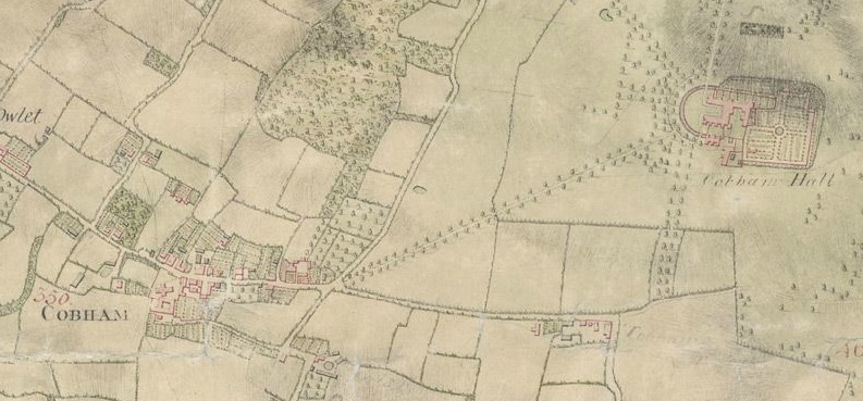
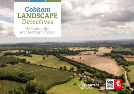
Cobham Landscape Detectives was a three year discovery project covering the Cobham landscape. Various techniques were used to study the village and the woods, including LiDAR, geophysics, fieldwalking, metal detecting, research, oral history, small scale trenching and test pitting.
Kent County Council secured a grant of £96,000 from the Heritage Lottery Fund for the project. Stuart McLeod, head of HLF South East, said:
“Thanks to National Lottery players, this project provides a wonderful opportunity for people to delve into their local heritage and we’re delighted to award this grant so that the volunteers can begin their journey of discovery.”
The summers of 2017 and 2018 saw the Cobham Village Digs. Cobham residents were encouraged to come forward and dig a test pit in their garden. Activities at the school, and a larger community dig were held in the village later in the summer. In 2016 the dig focused in Cobham Woood at the site of the Mausolem Cottage. For further details on the Mausoleum Cottage dig of 2016, click here.

Research undertaken about the area can be found below:
- Special finds 2017
- Prehistoric objectives in the Cobham Landscape
- The Manor of Cobham Hall
- The Saxon boundaries of Meopham
- Hundreds and lathes
- Schedule to Norton’s map of 1641
Other Cobham News:
- North Kent Nature Reserves Survey
- Cobham Woods
- Cobham online chat
- Monumental Brasses of Cobham Church
- A Cobham gentleman of the 1700s: Mr Hayes Diary
- Cobham, Kent
- Early footage of village life in Cobham
- Cobham booklet coming soon
- Several injured in crash near Cobham
- Cobham Exhibition June 2019
- Guided walk – Cobham archaeology and history
- Cobham wraps up and Amherst kicks off
- This Saturday 29th September
- Quick Cobham update
- Cobham Fete 2018
- Owletts this week
- Back to Sunnyside
- Ern and myself
- Now for another little yarn…
- A girl in Cobham village
- Living in Gravesend and Cobham
- The Hollow Way, Cobham Woods
- Catherine Weed Barnes Ward at Cobham c.1901
- Cobham Landscape Detectives research note 6: the Manor of Henhurst
- Village life in wartime Cobham
- Cobham Landscape Detectives research note 5: the Manor of Vyaunds
- Cobham’s historic water supply
- Betty Bicker-Robinson remembers the villagers of Cobham 1938-40
- Special finds from Cobham Big Dig 2017
- Jack Hollis: memories of Ashenbank and Shorne Woods
- Bettie Robinson: memories of The Old Curiosity Shop’, Cobham
- Cobham Fete this Bank Holiday
- Meadow Cottages, Cobham
- Pupils take part in Festival of Archaeology
- Finds processing for Cobham
- Day of Archaeology: the dig in Cobham
- The Lost Reservoir of Cobham
- CLD general update
- Mascot in residence
- Cobham School dig update
Just asking on the off chance someone may know the answer……. Does anyone know how Copt Hall Rd in Cobham got it’s name please?
Thanks for your question.
Roger, our team researcher, has looked into this for you. I hope this helps:
I imagine Copt Hall Road was so named because the house named Copt Hall lies about halfway along its length between Toltingtrough Green and Whitepost Lane. Its NGR position, as far as I can estimate, is 6502E 6852N and it is a flint and brick building, probably a farm house, lying a few metres SE of the lane (behind a hedge!). I do not know the building but it seems to consist of two cells, rather like a church. The window openings that I could see from Google Earth (through the entrance gate) were lined in red brick but the original house might be medieval. The Kent HER does not seem to be working at present, so I cannot confirm its age.
That still leaves you wondering how the house got its name. We would need to know how the name was spelled in earlier centuries, to make useful guesses at that. It is given as Cob Hall on the early one inch to a mile map published by David & Charles (based on a survey of 1789-1808, published in 1819 but revised in the 1840s and later), but that may just be a mis-hearing of the name. Google Earth also showed a hand-painted notice saying Copt Hall lying on the front lawn.
There are a surprising number of Copt Halls in southern England. There is a CH Farm in Marden, south of Maidstone (probably medieval) and another of uncertain date in Hawkhurst. Essex has a CH near Great Wigborough on the Blackwater estuary, with Copt Saltings and Copt Grove (apparently a forest) as well. There are others in Luton, Bedfordshire and Redbourne, Hertfordshire. Mr Wallenberg (after reading Hasted Vol III) found a single example of CH in Wickhambreaux. There is also Copped Hall at Epping in Essex, which is probably a variant of the same name and which goes back at least to the 12th century. Making a wild guess, I think a connection with ancient religious sects in Egypt is unlikely and perhaps a more mundane link with coppiced woodland might be the origin of the name. But we do need to see some early forms of the name.
Hello
My ancestor lived in cherry orchard estate in cobham in the 1700’s and left it in his will to his daughter .. does anyone know where this was ? The botting family